Class XII Session 2025-26
Subject – Geography
Time Allowed: 3 hours Maximum Marks: 70
General Instructions:
Read the following instructions carefully and follow them:
1. This question paper contains 30 questions. All questions are compulsory.
2. Question paper is divided into five sections A, B, C, D and E.
3. Section A Questions no. 1 to 17 are Multiple Choice type questions. Each question carries 1 mark.
4. Section B Questions no. 18 and 19 are Source-based questions. Each question carries 3 marks.
5. Section C Questions no. 20 to 23 are Short Answer type questions. Each question carries 3 marks. Answer to these questions shall be written in 80 to 100 words.
6. Section D Questions no. 24 to 28 are Long Answer type questions. Each question carries 5 marks. Answer to these questions shall be written in 120 to 150 words.
7. Section E Questions no. 29 and 30 are Map-based questions. Each question carries 5 marks.
8. There is no overall choice given in the question paper. However, an internal choice has been provided in a few questions in all sections other than Section A.
Section A
1. Assertion (A): Some people do not have the capability and freedom to make even basic choices. Reason (R): They have very limited choices and do not have the means to a decent life.
a) Both A and R are true and R is the correct explanation of A.
b) Both A and R are true but R is not the correct explanation of A.
c) A is true but R is false.
d) A is false but R is true.
View AnswerAns. c) A is true but R is false.
2. Match the following correctly.
a) (a) – (iii), (b) – (i), (c) – (ii), (d) – (iv)
b) (a) – (iii), (b) – (ii), (c) – (i), (d) – (iv)
c) (a) – (iv), (b) – (i), (c) – (ii), (d) – (iii)
d) (a) – (iv), (b) – (ii), (c) – (i), (d) – (iii)
View AnswerAns. a) (a) – (iii), (b) – (i), (c) – (ii), (d) – (iv)
3. What was the number of internet users in 1995 AD?
a) 20 million
b) 2 billion
c) 50 million
d) 120 million
View AnswerAns. c) 50 million
4. Consider the following statements and choose the correct option for the same:
i. More concentration of population resulted in compact or clustered rural settlements.
ii. Fertile plain provides a more agricultural output which attracts more population to live and engage in agriculture.
a) Both statements are correct and statement ii correctly explains the statement i
b) Both the statements are incorrect
c) Only i is correct
d) Only ii is correct
View AnswerAns. a) Both statements are correct and statement ii correctly explains the statement i
5. How many countries have a high level of human development(2020)?
a) 53
b) 37
c) 57
d) 67
View AnswerAns. a) 53
6. The kinetic energy of wind, through turbines, is converted into:
a) Mechanical energy
b) Electrical energy
c) Geothermal energy
d) Bio-energy
View AnswerAns. b) Electrical energy
7. Which state in India produces the highest quantity of crude oil?
a) Gujarat
b) Tripura
c) Assam
d) Maharashtra
View AnswerAns. a) Gujarat
8. Which of the following elements is both a water pollutant and air pollutant?
a) Carbon monoxide
b) Ammonia
c) Mercury
d) Sulphates
View AnswerAns. b) Ammonia
9. Which of the following is/are the advantages offered by water transport?
1. It does not require any construction and thus reduces costs.
2. The energy cost is low in water transport.
3. The oceans are linked and can be navigated in all directions.
a) 1 and 3
b) 2 and 3
c) 1 and 2
d) 1, 2 and 3
View AnswerAns. d) 1, 2 and 3
10. Consider the following statements and choose the correct option for the same:
i. Growth is a qualitative change, which is always positive.
ii. Development have a positive or a negative sign that the change may be either positive (showing an increase) or negative (indicating a decrease).
a) Only i is correct
b) Only ii is correct
c) Both i and ii are correct
d) Both are incorrect
View AnswerAns. d) Both are incorrect
11. Arrange the following countries in sequential order according to the gender gap index. Choose the correct option.
i. USA
ii. New Zealand
iii. Spain
iv. Germany
a) ii, iv, iii,
i b) i, iii, iv, ii
c) ii, iii, iv, i
d) ii, iii, i, iv
View AnswerAns. c) ii, iii, iv, i
12. Anthropogeography is written by
a) Ratzel
b) Bruches
c) Demanzia
d) Blache
View AnswerAns. a) Ratzel
13. Paper and medicine are industries based on:
a) Extracting
b) Forest
c) Querying
d) Mining
View AnswerAns. b) Forest
14. Which one of the following is the feature of clustered settlements?
a) Units are known as panna, para, palli etc
b) They are fragmented
c) Closely built-up area of houses
d) They are isolated
View AnswerAns. c) Closely built-up area of houses
15. Match column I with column II and choose the correct option.
a) (a) – (iii), (b) – (iv), (c) – (ii), (d) – (i)
b) (a) – (iv), (b) – (iii), (c) – (ii), (d) – (i)
c) (a) – (i), (b) – (ii), (c) – (iii), (d) – (iv)
d) (a) – (i), (b) – (iii), (c) – (ii), (d) – (iv)
View AnswerAns. b) (a) – (iv), (b) – (iii), (c) – (ii), (d) – (i)
16. The wasteland in India covers:
a) 15.9%
b) 7.5%
c) 10.5%
d) 16.96%
View AnswerAns. d) 16.96%
17. Complete the chart using the options given below.
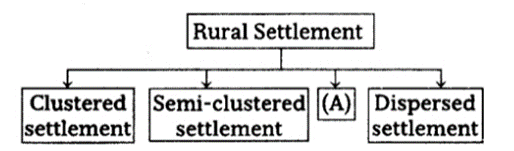
a) Fragmented settlement
b) Nucleated settlement
c) Hamleted settlement
d) Isolated settlement
View AnswerAns. c) Hamleted settlement
Section B
18. Read the following text carefully and answer the questions that follow: All economic activities namely primary, secondary, tertiary and quaternary, revolve around obtaining and utilising resources necessary for survival.
Secondary activities add value to natural resources by transforming raw materials into valuable products. Cotton in the boll has limited use but after it is transformed into yarn, becomes more valuable and can be used for making clothes. Iron ore, cannot be used; directly from the mines, but after being converted into steel it gets its value and can be used for making many valuable machines, tools, etc. The same is true of most of the materials from the farm, forest, mine and the sea. Secondary activities, therefore, are concerned with manufacturing, processing and construction (infrastructure) industries.
i. What are secondary activities?
View AnswerAns. Activities that transform the raw materials into valuable products are called secondary activities. The manufacturing and Industry sector known as the secondary sector, or the production sector, includes all branches of human activities that transform raw materials into products or goods.
ii. What is the importance of secondary activities in the world?
View AnswerAns. The importance of secondary activities is that these activities add value to the natural resources by the transformation of raw materials into useful and valuable products.
iii. Which processes help secondary activities?
View AnswerAns. Secondary activities change the form and value of raw material by the following process:
a. manufacturing
b. processing
c. construction (infrastructure)
19. Study the given picture and answer the questions that follow:
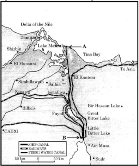
i. Name the waterway given in the picture.
View AnswerAns. Suez Canal
ii. Name the two sea connected by this waterway.
View AnswerAns. Mediterranean Sea and Red Sea
iii. Name the ports marked as A & B in this picture.
View AnswerAns. A. Port Said
B. Port Suez
Section C
20. The assessment, efficient use, and conservation of water are necessary to ensure development. Explain in the light of values regarding the conservation of water resources.
View AnswerAns. Conservation of water resources is necessary because:
i. There is a vast disparity between population and availability of water resources as India has about 16 percent of the world’s population, but has only 4 percent of the world’s water resources.
ii. The total utilisable water resources in India are very limited.
iii. The population is increasing at a faster rate and the demand is also increasing day by day.
iv. Pollution is making water resource unusable
OR
Explain any three factors responsible for the depletion of water resources in India.
View AnswerAns. Factors responsible for the depletion of water resources in India
i. Water gets polluted by foreign matters, such as micro-organisms, chemicals, industrial and other wastes. Such matters deteriorate the quality of water and render it unfit for human use.
ii. When toxic substances enter lakes, streams, rivers, ocean and other water bodies, they get dissolved or lie suspended in water.
iii. This results in pollution of water, whereby quality of water deteriorates affecting aquatic systems. Sometimes, these pollutants also seep down and pollute groundwater.
21. Study the chart given below and answer the questions that follow:
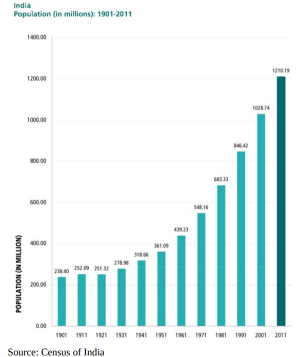
i. What do you mean by the decadal growth rate?
View AnswerAns. The decadal growth rate is a vital part of Census operations. This gives an overview of the percentage of total population growth in a particular decade.
ii. Explain why the decades 1951-81 are referred to as the period of population explosion in India?
View AnswerAns. A rapid fall in the mortality rate but a high fertility rate of population in the country. It is in this period, after the, Independence that developmental activities were introduced through a centralised planning process and economy started showing up ensuring the improvement of living condition of people at large. Consequently, there was a high natural increase and higher growth rate.
iii. In which decade the population growth rate has increased to 181 million? Give a reason why it has increased?
View AnswerAns. During 2001-2011 period because downward trend of crude birth rate is held responsible for such a population growth. This was, in turn, affected by an increase in the mean age at marriage, improved quality of life particularly education of females in the country.
22. Describe in brief the changing nature of export items in the international trade of India.
View AnswerAns. The changing pattern of the composition of India’s exports can be understood through the following points:
i. There is a decrease in the share of agriculture and allied products.
ii. The share of petroleum products has increased mainly because of the rise in petroleum prices and increase in the petroleum refining capacity of India.
iii. A huge decline is registered in the exports of traditional items like coffee, spices, tea, pulses, etc due to the tough international competition.
iv. The increase has been registered in floricultural products, fresh fruits, marine products, and sugar, etc.
v. Gems and jewellery are other commodities that have a larger share in India’s international trade.
23. Give the meaning of a digital divide.
View AnswerAns. A digital divide is an economic and social inequality according to categories of persons in a given population for their access to the use of, or knowledge of information and communication technologies (ICT). The divide within countries may refer to inequalities between individuals, households, businesses, geographical areas, usually at different socioeconomic levels or other demographic categories. Digital divide implies a division on the basis of availability of access to Information & technology, whether on the cause of Illiteracy or adequate training or denial of access due to non-availability of finance to meet the access.
OR
There is low yield per acre but high yield per person in the interior parts of semi-arid lands of the mid latitudes in the world.” Support the statement with suitable examples.
View AnswerAns. The interior parts of semi-arid lands of the mid latitudes in the world are the areas where extensive commercial grain cultivation takes place.
Here the size of farms is very large and population is in small number. That is why entire operations of cultivation right from ploughing to harvesting is mechanised. Therefore, yield per person is high as the number of people working in farms is less and lot of machines are used.
However, the size of the farms are very large due to which per acre production or yield is low even though the total production is high. This type of agriculture is practised in Eurasian Steppes, Canadian and American Prairies, Pampas of Argentina, Velds of South Africa, Australian Downs and the Canterbury Plains of New Zealand. Wheat is the principal crop and other crops are corn, barley, oats and rye.
Section D
24. Mediterranean agriculture is highly specialized commercial agriculture in the world. Support the statement.
View AnswerAns. Mediterranean Agriculture:
– It is practised in the countries on either side of the Mediterranean Sea in Europe and in North Africa from Tunisia to the Atlantic coast southern California central Chile southwestern parts of South Africa and south and southwestern parts of Australia.
– This region is an important supplier of citrus fruits.
– Viticulture or grape cultivation is a speciality of the Mediterranean region.
– Best quality wines in the world with distinctive flavours are produced from high-quality grapes in various countries of this region.
– The inferior grapes are dried into raisins and currants. This region also produces olives and figs.
– The advantage of Mediterranean agriculture is that more valuable crops such as fruits and vegetables are grown in winters when there is great demand in European and North American markets.
25. Land transport plays a vital role in the development of trade and tourism in the world. Support the statement with suitable examples.
View AnswerAns. i. Land transport is the transport or movement of people, animals or goods from one location to another location on land.
ii. Development of the efficient means of transport has knit together all the nations of the world into one big world market.
iii. Even the perishable articles like fish, dairy products, meat, etc., are being transported to distant places of the world. But without good transport facilities, such as development in trade and commerce would not be possible. In India, there are many highways linking the major towns and cities. For example, the Golden Quadrilateral (GQ) or Super Expressways connects the four metropolitan cities-New Delhi, Mumbai, Bangalore, Chennai, Kolkata and Hyderabad which has helped in the development of the trade.
iv. Tourism is much about travel and therefore the role of transportation in its operation is vital. For eg, Car transport is the dominant mode in world tourism because of advantages such as flexibility, price, and independence.
OR
Waterways is an important mode of transport for both passenger and cargo traffic in India. Support the statement with examples.
View AnswerAns. Waterways are important mode of transport for both passengers and cargo traffic in India in the following ways:
– Waterways provide cheapest and most suitable transportation for heavy and bulky material for long distances from one region to another.
– It is a fuel efficient and eco-friendly means of transport as it does not require maintenance and construction of routes, which involves high cost.
– India has 14,500 km of Inland waterways which accounts for 1% of country’s transportation.
– At present, over 5,600 km of rivers are navigable by mechanised vessels in India. Which are used to transport both passenger and freight.
– Backwaters (Kayal) of Kerala have special significance as they provide cheap means of transport as well as tourism activities.
– It reduces congestion and accidents on roads highways as freight can be moved easily with waterways.
– It can be used for transporting both domestic as well as international cargo. India has many major and minor parts, which are facilitating trade within the country as well as internationally.
– Waterways have potential for cruise, tourism and passenger traffic that can contribute to the development of the country.
26. Explain balance of trade with examples and examine the role of World Trade Organisation (WTO) in international trade.
View AnswerAns. Balance of Trade:
i. Balance of trade records the volume of goods and services imported as well as exported by a country to other countries.
ii. If the value of imports is more than the value of a country’s exports, the country has a negative or unfavourable balance of trade.
iii. If the value of export is more than the value of imports then the country has a positive or favourable balance of trade.
Role of World Trade Organisation (WTO) in international trade:
i. It ensures free and fair trade amongst the member nations.
ii. It sets the rules for global trading system.
iii. It resolves the disputes between the member nations.
iv. WTO also covers trade in services, such as telecommunication and banking, and others issues such as intellectual
OR
What is the role of the World Trade Organisation as an international organisation? Why has the World Trade Organisation been criticised by some countries?
View AnswerAns. In1948, to liberalise the world from high customs tariffs and various other types of restrictions, General Agreement for Tariffs and Trade (GATT) was formed by some countries. In 1994, it was decided by the member countries to set up a permanent institution for looking after the promotion of free and fair trade amongst nation and the GATT was transformed into the World Trade Organisation (WTO) from 1st January 1995. WTO is the only international organisation dealing with the global rules of trade between nations.
The functions of WTO are as follows:
i. It sets the rules for the global trading system.
ii. It promotes free and fair trade amongst different countries of the world.
iii. WTO also covers trade in services, such as telecommunication and banking, and other issues such as intellectual rights.
World Trade Organisation has always been criticised by those who are worried about the effects of free trade and economic globalisation. The critique of WTO is based on an argument that free trade is not beneficial to ordinary people as it is widening the gulf between rich and poor by making rich countries more richer. This is because influential nations try to satisfy their commercial interests through WTO. In addition, these countries have not fully opened their markets to developing countries. Critics also argue that important issues like health, workers’ rights, child labour and environment have been ignored by WTO.
27. Describe the various changes of economy affecting the land use in India.
View AnswerAns. Three types of changes that an economy undergoes, which affect land-use are:
i. The size of the economy measured in terms of value for all the goods and services produced in the economy grows over time as a result of increasing population, change in income levels, available technology and associated factors. As a result, the pressure on land will increase with time and marginal lands would come underuse.
ii. Secondly, the composition of the economy would undergo a change over time. In other words, the secondary and the tertiary sectors usually grow much faster than the primary sector, specifically the agricultural sector. This type of change is common in developing countries like India. This process would result in a gradual shift of land from agricultural uses to non-agricultural uses. The agricultural land is being used for building purposes.
iii. Thirdly, though the contribution of the agricultural activities reduces over time, the pressure on land for agricultural activities does not decline. The reasons for continued pressure on agricultural land are, In developing countries, the share of population dependent on agriculture usually declines much more slowly compared to the decline in the sector’s share in GDP and the number of people that the agricultural sector has to feed is increasing day by day
28. How can integrated area approach and local planning reduce regional disparities in India? Explain with three suitable examples.
View AnswerAns. Integrated area approach and local planning is important measures for reducing regional disparities in India. It is related them to the preparation of an integrated plan for selected areas and to the formulation of district plans. A few integrated plans are as under:
i. Hill Area Development Programme: It was initiated in hilly areas of Uttaranchal, Assam, West Bengal and Tamil Nadu. The main objectives of this were:
a. To exploit local resources of the hill areas.
b. To start the primary activities such as horticulture, forestry, animal husbandry.
c. To imitate the conservation measures.
d. To began suitable village industries.
ii. Tribal Area Development Programme: This programme has been taken upon those areas where tribal population is more than 50% such as in Madhya Pradesh, Chhattisgarh, Orissa, Gujarat, Maharashtra, Andhra Pradesh, Jharkhand and Rajasthan.
iii. Drought Prone Area Programme: The aim was to provide employment to the rural people in drought-prone areas, to introduce relief operations.
iv. Metropolitan Regional Planning: Urban master plans were prepared for capital and port cities to reduce the problem of rapid urbanisation and to control large scale immigration from rural to urban. A master plan was prepared for Delhi in 1955 to develop the satellite towns around Delhi.
OR
Mention the measures proposed to promote sustainable development in the Command Area of Indira Gandhi Canal irrigation project which are meant to restore ecological balance.
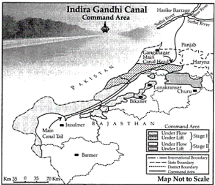
Ans. i. The first requirement is the strict implementation of water management policy. The canal project envisages protective irrigation in Stage-1 and extensive irrigation of crops and pasture development in Stage-II.
ii. In general, the cropping pattern shall not include water-intensive crops. It shall be adhered to and people shall be encouraged to grow plantation crops such as citrus fruits.
iii. The CAD programmes such as the lining of watercourses, land development levelling and Warabandi system shall be effectively implemented to reduce the conveyance loss of water.
iv. The areas affected by waterlogging and soil salinity shall be reclaimed.
v. The eco-development through afforestation, shelterbelt plantation and pasture development is necessary, particularly in the fragile environment of Stage-II.
vi. The social sustainability in the region can be achieved only if the land allottees having poor economic background are provided adequate financial and institutional support for the cultivation of land.
Section E
29. On the given political outline map of the World, seven geographical features have been marked as A, B, C, D, E, F and G. Identify any five with the help of the following information and write their correct names on the lines drawn near them:
A. An area of extensive commercial grain farming
B. A terminal station of Trans-Siberian Railway
C. An area of nomadic herding
D. An area of commercial livestock rearing
E. A major sea port of Asia
F. A major international airport of Europe
G. A major shipping canal
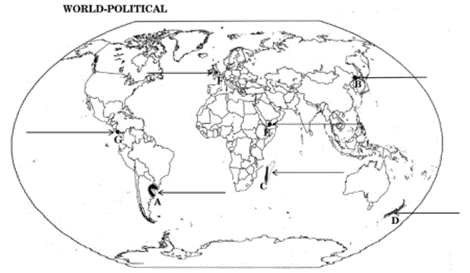
Ans. A. PAMPAS
B. Trans Siberian railway -VLADIVOSTOK
C. MADAGASCAR
D. NEW ZEALAND
E. ADEN
F. LONDON
G. PANAMA
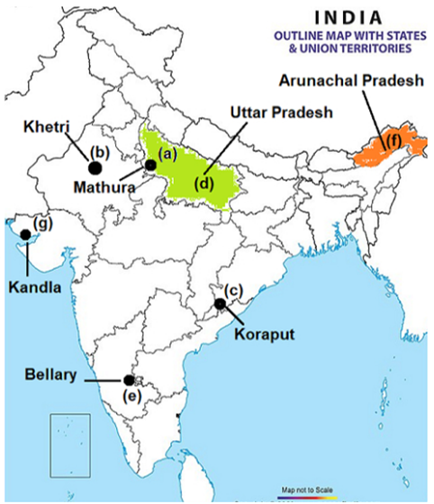
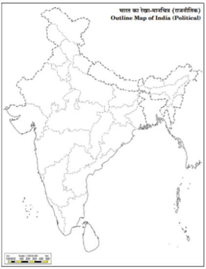
30. Locate and label any five of the following geographical features on the Political Outline map of India with appropriate symbols:
a. Oil refinery located in Uttar Pradesh
b. Khetri Copper mines
c. Bauxite mines located in Odisha
d. The state leading in the production of Wheat
e. Bellary Iron-ore mines
f. The state with lowest population density
g. An important seaport in Gujarat
Ans.