Class XII Session 2025-26
Subject – Geography
Time Allowed: 3 hours Maximum Marks: 70
General Instructions:
Read the following instructions carefully and follow them:
1. This question paper contains 30 questions. All questions are compulsory.
2. Question paper is divided into five sections A, B, C, D and E.
3. Section A Questions no. 1 to 17 are Multiple Choice type questions. Each question carries 1 mark.
4. Section B Questions no. 18 and 19 are Source-based questions. Each question carries 3 marks.
5. Section C Questions no. 20 to 23 are Short Answer type questions. Each question carries 3 marks. Answer to these questions shall be written in 80 to 100 words.
6. Section D Questions no. 24 to 28 are Long Answer type questions. Each question carries 5 marks. Answer to these questions shall be written in 120 to 150 words.
7. Section E Questions no. 29 and 30 are Map-based questions. Each question carries 5 marks.
8. There is no overall choice given in the question paper. However, an internal choice has been provided in a few questions in all sections other than Section A.
Section A
1. Assertion (A): Literacy is essential for eradicating poverty.
Reason (R): It is a reliable indicator of the socio-cultural, economic, and cultural development of a country.
a) Both A and R are true and R is the correct explanation of A.
b) Both A and R are true but R is not the correct explanation of A.
c) A is true but R is false.
d) A is false but R is true.
View AnswerAns. b) Both A and R are true but R is not the correct explanation of A.
2. Choose the correct option related to the expansion of the Orient Express.
a) Sydney to Melbourne
b) Moscow to Kazan
c) Winnipeg to Cudbury
d) Paris to Istanbul
View AnswerAns. d) Paris to Istanbul
3. Match the following:
a) (a) – (i), (b) – (ii), (c) – (iii), (d) – (iv)
b) (a) – (iii), (b) – (iv), (c) – (ii), (d) – (i)
c) (a) – (iv), (b) – (ii), (c) – (iii), (d) – (i)
d) (a) – (iii), (b) – (i), (c) – (ii), (d) – (iv)
View AnswerAns. c) (a) – (iv), (b) – (ii), (c) – (iii), (d) – (i)
4. Consider the following statements and choose the correct option for the same:
i. The thought of Possibilism in which man was taken as free, uncontrolled, and master of unlimited powers has been criticized.
ii. A consequence of free run of developed economies many problems are being faced today like greenhouse effect, ozone layer depletion etc.
a) Both statements are correct and statement ii correctly explains the statement i
b) Only i is correct
c) Both the statements are incorrect
d) Only ii is correct
View AnswerAns. a) Both statements are correct and statement ii correctly explains the statement i
5. How is access to resources measured?
a) Medical facilities
b) Good goverance
c) Education
d) Purchasing power
View AnswerAns. d) Purchasing power
6. Which one of the following is a ferrous mineral?
a) Bauxite
b) Mica
c) Coal
d) Iron ore
View AnswerAns. d) Iron ore
7. In which one of the following states Badampahar iron-ore mines are located?
a) Chhattisgarh
b) Odisha
c) Telangana
d) Jharkhand
View AnswerAns. b) Odisha
8. Which one of the following diseases is caused by water pollution?
a) Conjunctivitis
b) Bronchitis
c) Diarrhorea
d) Respiratory infections
View AnswerAns. c) Diarrhorea
9. Which one of the following is known as Big Inch pipeline?
a) Iran China – via Afghanistan
b) Hazira – Vijaypur to Jagdishpur
c) Iran India – via Pakistan
d) Gulf of Mexico to northeastern USA
View AnswerAns. d) Gulf of Mexico to northeastern USA
10. Consider the following statements and choose the correct option for the same:
i. The land holdings in intensive subsistence agriculture dominated by wet paddy cultivation are very high.
ii. The population density is very low in intensive subsistence agriculture regions.
a) Only i is correct
b) Only ii is correct
c) Both statements i and ii are incorrect
d) Both statements are correct and statement ii correctly explains the statement i
View AnswerAns. c) Both statements i and ii are incorrect
11. Arrange the following regions in the order of decreasing density of their populations.
1. Africa
2. Asia
3. Europe
4. North America
5. Oceania
a) 1, 2, 3, 5, 4
b) 2, 3, 1, 5, 4
c) 1, 3, 2, 4, 5
d) 2, 1, 3, 4, 5
View AnswerAns. d) 2, 1, 3, 4, 5
12. Manganese is mainly used in which of these activities?
1. Smelting of iron ore
2. Producing ferro alloys
3. Manufacturing aluminium
a) 1, 2 and 3
b) 1 and 2
c) 1 and 3
d) 2 and 3
View AnswerAns. b) 1 and 2
13. Which one of the following is not the objective of Haryali watershed development project?
a) Drinking water
b) Irrigation
c) Industries
d) Fishing
View AnswerAns. c) Industries
14. What stands for the CPCB?
a) The Central Pollution Control Board
b) The Central Polythene Control Board
c) The Commandant Pollution Control Board
d) The Central Plastic Control Board
View AnswerAns. a) The Central Pollution Control Board
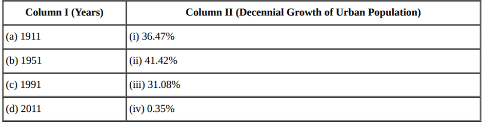
Question No. 15 to 17 are based on the given text. Read the text carefully and answer the questions:
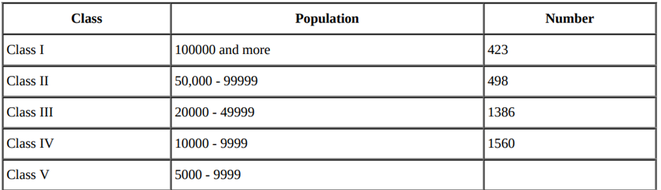
15. Which class cities are highest in number?
a) Class III cities
b) Class V cities
c) Class II cities
d) Class IV cities
View AnswerAns. d) Class IV cities
16. Suppose City X has the population of 5576 in the 2001. City X will be classified in which category?
a) Class IV cities
b) Class II cities
c) Class V cities
d) Class III cities
View AnswerAns. c) Class V cities
17. India has ________. Among them, 35 cities or urban agglomeration are metropolitan cities.
a) 423 megacities
b) 423 megapolis
c) 423 villages
d) 423 cities
View AnswerAns. d) 423 cities
18. Manufacturing involves a full array of production from handicrafts to moulding iron and steel and stamping out plastic toys to assembling delicate computer components or space vehicles. In each of these processes, the common characteristics are the application of power, mass production of identical products and specialised labour in factory settings for the production of standardised commodities. Manufacturing may be done with modern power and machinery or it may still be very primitive. Most of the Third World countries still ‘manufacture’ in the literal sense of the term. It is difficult to present a full picture of all the manufacturers in these countries. More emphasis is given to the kind of ‘industrial’ activity which involves less complicated systems of production.
i. What is manufacturing?
View AnswerAns. The process of converting raw materials, components, or parts into finished goods that meet a customer’s expectations or specifications. Manufacturing commonly employs a man-machine setup with division of labor in a large scale production. Manufacturing refers to mass production of any kind of identical goods with the use of power, specialised labour and a factory. It is done in either by hand or power driven machinery. Industry refers to simple processing of natural raw materials.
ii. What is the smallest unit of manufacturing?
View AnswerAns. Cottage industries is the smallest unit of manufacturing.
iii. What are the characteristics of modern large scale manufacturing?
View AnswerAns. The characteristics of modern large scale manufacturing are:
a. Mechanization
b. Specialisation of Skills/Methods of Production
c. Technological innovations
d. Organisational structure and stratification
e. Uneven geographical distribution
19. Study the map given below carefully and answer the following questions.
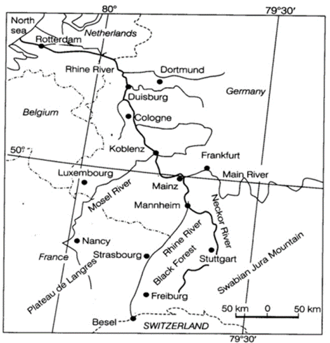
i. Name the inland waterway shown in the map.
View AnswerAns. The Rhine inland waterway is shown in the map.
ii. This waterway connects industrial areas of which countries of Europe?
View AnswerAns. It connects the industrial areas of Switzerland, Germany, France, Belgium and the Netherlands.
iii. State any two characteristics of this waterway.
View AnswerAns. Characteristics of this waterway are as follows:
a. Rhine river flows through a rich coalfield making whole basin prosperous manufacturing area.
b. This waterway is the world’s most heavily used, e.g. more than 20,000 ocean-going vessels and 2,00,000 inland vessels exchange their cargoes each year.
Section C
20. Explain with the help of examples how nature gets humanised.
View AnswerAns. Human beings interact with their physical environment with the help of technology. Human beings with social and cultural development developed better and more efficient technology. They moved from a state of necessity to a state of freedom. They created possibilities with the resources obtained from the environment. All these modern technologies helped humans to construct dams, reservoirs, canals, etc. Weather modified programmes help in cloud seeding to induce precipitation, fogs, checking of hailstorms, nuclear programmes etc. Humans made use of the opportunities provided by nature and slowly nature got humanised and started bearing the imprints of human endeavour.
OR
Examine the mains aspects of environmental determinism.
View AnswerAns. i. There is always interaction between humans and natural phenomena.
ii. Primitive societies were intimately dependent on nature for food and other resources.
iii. We can imagine the presence of a naturalized human who listened to nature, was afraid of its fury and worshipped it.
iv. Strong forces of nature always guided human activities.
v. This relation was termed as environmental determinism
21. Study the following chart and answer:
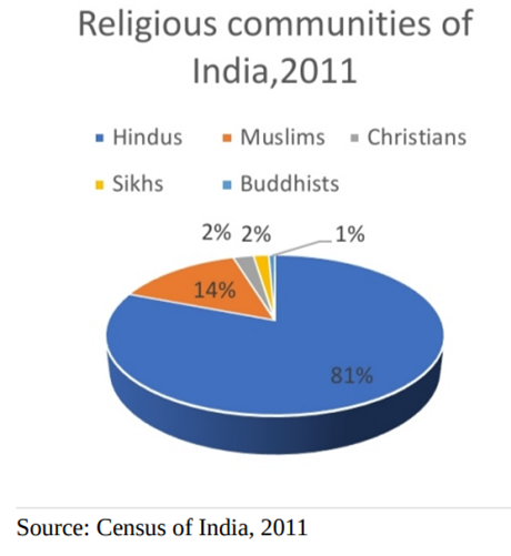
i. Which are the smallest religious groups in India?
View AnswerAns. The smallest religious groups in India are Sikhs and Buddhists.
ii. In which area Christian population is mostly concentrated?
View AnswerAns. The Christian population is distributed mostly in rural areas of the country. The main concentration is observed along the Western coast around Goa, Kerala and in the north-eastern region.
iii. Why it is important to study the religious composition of any country?
Ans. Religion is one of the most dominant forces affecting the cultural and political life of the majority of Indians. It also permeates into almost all the aspects of people’s family and community lives, it is important to study the religious composition.
[/expand]22. Why is Kochi considered as a major port?
View AnswerAns. Kochi is a major port because:
a. It has an excellent location with a natural harbour. It is situated at the head of Vembanad Kayal, popularly known as the ‘Queen of the Arabian Sea’.
b. It is close to the Suez-Colombo route.
c. Serves the three southern states of India (Kerala, southern-Karnataka and south western Tamil Nadu)
23. What do you know about medical services for overseas patients?
View AnswerAns. India has emerged as the leading country of medical tourism in the world. World-class hospitals located in the Metropolitan cities and Vellore cater to patients all over the world. Medical tourism brings abundant benefits to developing countries like India, Thailand, Singapore, and Malaysia. India is giving Thailand stiff competition in healthcare services for overseas patients with the cost of surgery lower by over 30% and in fact cheapest in entire Southeast Asia.
Section D
24. Examine the main characteristics of Co- operative Farming in the world.
View AnswerAns. The features of cooperative farming are as follows:
Pooling Resources: In cooperative farming, a group of farmers pool their resources voluntarily. Farming is a matter of cooperative initiative.
Efficient and Profit Oriented: It is more efficient and profit oriented than individual farming.
Support of Cooperative Societies: The cooperative societies help farmers to procure important inputs of farming, sell the products at more favourable terms and help in processing of quality products at cheaper rates.
Practised in Western Countries: This type of farming is mainly practised in the western countries such as Denmark, Netherlands, Belgium, Sweden, Italy etc. In Denmark, the movement has been so successful that practically every farmer is a member of a cooperative.
25. Describe the main features of development of railways in India.
View AnswerAns. The main features of Indian Railway:
i. Indian Railways have a total length of 68,155 km.
ii. It is the largest railway system in Asia and the fourth largest in the world.
iii. Indian railways have 13,452 passenger trains and 9,141 freight trains plying 23 million travellers and 3 million tonnes (MT) of freight daily from 7,349 stations.
iv. It had 12.27 lakh employees as of March 2019, making it the world’s eighth-largest employer
v. Indian Railways’ gross revenue stood at Rs 183,092.74 crore (US$ 26.20 billion) in FY20 (till February 2020).
vi. Indian railways have about 12,147 locomotives, 74,003 coaches and 2,89,185 wagons.
vii. Most of the railways are found in the level Gangetic plain.
viii. IR is divided into 17 zones.
ix. India has 4,259 diesel locomotives, 2,302 electric locomotives and 347 steam locomotives. The electric trains run over a distance of 11,772 km.
x. Indian railways run of three gauges: Broad gauge-1.67 metres wide; Metre gauge-1 metre wide; Narrow gauge-0.76 metre wide.
OR
Name the canal linking the Mediterranean Sea and the Red Sea. Explain its main features.
View AnswerAns. Suez Canal links the Mediterranean Sea and the Red Sea.
Characteristics:-
i. It gives Europe a new gateway to the Indian Ocean.
ii. Reduces direct sea route distance between Liverpool and Colombo compared to the Cape of Good Hope route.
iii. It is a sea-level canal without locks.
iv. It saves time
26. Why are ports known as gateways of international trade? Explain any three characteristics of inland ports.
View AnswerAns. Ports are the chief gateways of the world of international trade. They are called so due to the following reasons:
i. These ports facilitate the passage of cargos and travellers from one country to another.
ii. These ports provide facilities of docking, loading, unloading and storage facilities for cargo, which are meant to export or import. In order to provide these facilities, the port authorities make arrangements for maintaining navigable channels, arranging tugs and barges and providing labour and managerial services.
iii. Large ports offer particularly attractive locations for lead industries and distribution-intensive enterprises.
Important characteristics of the inland ports are as follows:
i. These ports are located away from the sea coast. They are linked to the sea through a river or a canal.
ii. Such ports are accessible to flat bottom ships or barges.
iii. For example, Manchester is linked with a canal; Memphis is located on the river Mississippi; the Rhine has several ports like Mannheim and Duisburg; and Kolkata is located on the river Hoogli, a branch of the river Ganga.
OR
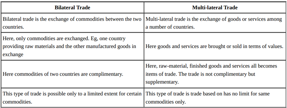
Differentiate between bilateral trade and multi-lateral trade. For which type of trade do we need ports?
View AnswerAns.
27. Explain the problems of Indian agriculture. AIso give remedies for it.
View AnswerAns. 1.Dependence on Erratic Monsoon : Irrigation covers only about 33 per cent of the cultivated area in India. The crop production in rest of the cultivated land directly depends on rainfall. Poor performance of south-west Monsoon also adversely affects the supply of canal water for irrigation.
2. Low productivity : The yield of the crops in the country is low in comparison to the international level. Per hectare output of most of the crops such as rice, wheat, cotton and oilseeds in India is much lower than that of U.S.A., Russia and Japan. Because of the very high pressure on the land resources, the labour productivity in Indian agriculture is also very low in comparison to international level. The vast rainfed areas of the country, particularly drylands which mostly grow coarse cereals, pulses and oilseeds have very low yields.
3. Constraints of Financial Resources and Indebtedness : The inputs of modern agriculture are very expensive. This resource intensive approach has become unmanageable for marginal and small farmers as they have very meagre or no saving to invest in agriculture. To tide over these difficulties, most of such farmers have resorted to availing credit from various institutions and money lenders. Crop failures and low returns from agriculture have forced them to fall in the trap of indebtedness. 4. Vast Under-employment : There is a massive under-employment in the agricultural sector in India, particularly in the un-irrigated tracts. In these areas, there is a seasonal unemployment ranging from 4 to 8 months. Even in the cropping season work is not available throughout, as agricultural operations are not labour intensive. Hence, the people engaged in agriculture do not have the opportunity to work round the year.
5. Small Farm Size and Fragmentation of Landholdings : There are a large number of marginal and small farmers in the country. More than 60 per cent of the ownership holdings have a size smaller than one (ha). Furthermore, about 40 per cent of the farmers have operational holding size smaller than 0.5 hectare (ha). The average size of land holding is shrinking further under increasing population pressure. Furthermore, in India, the land holdings are mostly fragmented. There are some states where consolidation of holding has not been carried out even once. Even the states where it has been carried out once, second consolidation is required as land holdings have fragmented again in the process of division of land among the owners of next generations. The small size fragmented landholdings are uneconomic.
OR
Classify Indian farming into two groups on the basis of the main source of moisture for crops. Write two feature of each.
View AnswerAns. In India, farming is classified into the following two groups on the basis of moisture available for crops:
i. Irrigated Farming: The features of the irrigated farming are as follows:
a. In this type of farming, the main source of moisture for the crop is irrigation by various methods like wells, tube-wells, etc.
b. Irrigated farming may be of two types on the basis of objective of farming i.e. productive and protective. Productivity can be enhanced by productive irrigation and crops can be saved from drought by providing them protective irrigation.
ii. Rainfed Farming: The features of rainfed farming are as follows:
a. In this type of farming, the main source of moisture for soil and crops is rainfall.
b. Rainfed fanning is done in the areas of drylands and wetlands in India. Dryland farming, areas that receive an annual rainfall of less than 75 cm. Crops cultivated are drought resistant. Wetlands are areas that receive sufficient rainfall to cultivate crops. Main crops are rice, jute, sugarcane and other water-intensive crops.
28. What is Sustainable Development? Explain any two aspects of the concept of sustainable development.
View AnswerAns. The notion of sustainable development emerged in the wake of general rise in the awareness of environmental issues in the late 1960s in the Western World. It reflected the concern of people about the undesirable effects of industrial development on the environment.
Sustainable development takes care of ecological, social, and economic aspects of development during the present times and pleads for conservation of resources to enable the future generations to use these resources. It takes into account the development of whole humankind which have common future.
Ecological Aspect: The environmental aspect of sustainable development commits to protecting the environment by reducing risks and measuring the environmental impacts of human activities. It aims to improve human welfare through the protection of natural capital (e.g. land, air, water, minerals etc.).
Economic Aspect: Development should take care of the protection of the environment encouraged by various methods like recycling of products, the use of renewable energy etc.
Social Aspect: Development should promote equality and respect for individual rights.
(any Two aspect)
OR
Write in brief about the physical setting of Bharmaur region.
View AnswerAns. Bharmaur region lies between 32°IT N and 32°4T N latitudes and 76°22’ E and 76°53′ E longitudes. It is spread over an area of about 1818 sq km. This region is the homeland of the Gaddi tribal community and is surrounded by lofty mountains on all sides. It has Pir Panjal in the North and Dhauladhar in the South. In the east, the extension of Dhauladhar converges with Pir Panjal near Rohtang Pass. The river Ravi and its tributaries, the Budhil and Tundahen, drain the territory and have carved out deep gorges. These rivers divide the region into the four physiographic divisions such as Holi, Khani, Kugti, and Tundah areas. The area has cold climate where the mean monthly temperatures for January and July are 4°C and 26°C respectively. Snowfall in winter is a common phenomenon.
Section E
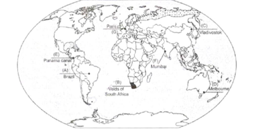
29. On the given political outline map of the world seven geographical features have been marked as A, B, C, D, E, F and G. Identify any five of them with the help of the following information and write their correct names on the lines drawn near them:
A. The largest country of South America
B. An area of extensive commercial farming
C. Easternmost station of Trans-Siberian Railway.
D. A major sea-port
E. The shipping canal
F. An international airport of Asia
G. An international airport of Europe
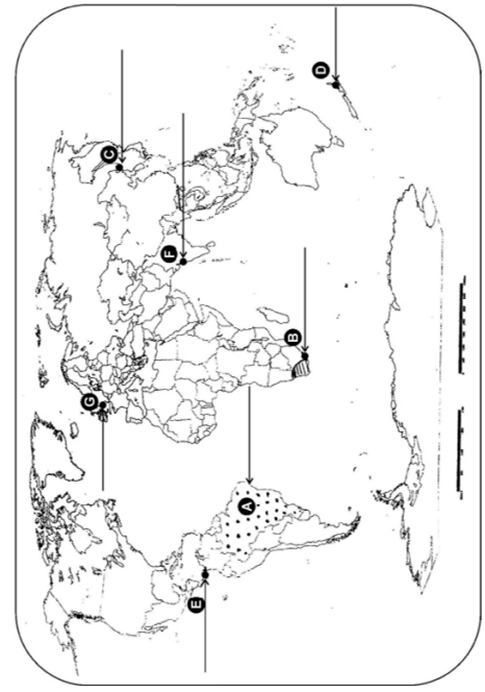
Ans. A. brazil
B. veles of south africa
C. vladivostok
D. Melbourne
E. Panama canal
F. mumbai
G. Paris
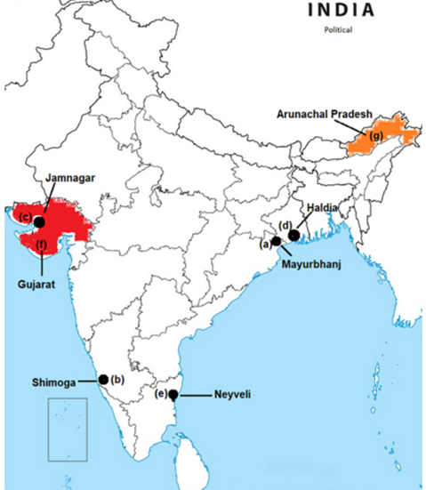
30. Locate and label any five of the following geographical features on the Political Outline map of India with appropriate symbols:
a. Mayurbhanj Iron-ore mines
b. Shimoga Manganese mines
c. Jamnagar Oil refinery
d. An important seaport in West Bengal
e. Name an important coal mine in Tamil Nadu
f. The state leading in the production of Cotton
g. The state with lowest population density
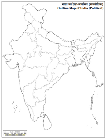
Ans.