SECTION -A
(Questions number 1 to 17 are Multiple Choice Type Questions.)
1, The Welfare or humanistic school of thought in human geography was mainly concerned with which different aspects?
(a) Social well-being of the people
(b) Basic cause of poverty, deprivation and social inequality.
(c) Development of capitalism.
(d) Perception of space by social categories based on ethnicity, race and religion, etc.
View AnswerAns. (a) Social well-being of the people
2. There are two statements marked as Assertion (A) and Reason (R). Mark your answer as per the codes provided below.
Assertion (A): Some places attract more people because they have religious or cultural significance.
Reason (R): People tend to move away from places where there is social and political unrest.
Options:
(a) Both (A) and (R) are true but (R) is not the correct explanation of (A).
(b) Both (A) and (R) are true and (R) is the correct explanation of (A).
(c) Both (A) and (R) are incorrect.
(d) (A) is correct but (R) is incorrect.
View AnswerAns. (a) Both (A) and (R) are true but (R) is not the correct explanation of (A).
3. Which of the following statements are correct related to urban marketing centres? Choose the correct option.
(I) Urban marketing centres have more widely specialised urban services.
(II) Urban marketing Centres provide ordinary goods and services as well as many of the specialised goods and services required by people.
(III) They offer manufactured goods as well as many specialised markets developed services.
(IV) Personal and professional services are not well-developed.
Options:
(a) Only statement (II) is correct.
(b) Only statement (I) is correct.
(c) Only statements (I), (II) and (III) are correct.
(d) Only statements (III) and (IV) are correct.
View AnswerAns. (c) Only statements (I), (II) and (III) are correct.
4. Arrange the following facts related to the history of land transport in sequence.
(I) Humans themselves were carriers.
(II) Animals like mules, horses and camels were used as beasts of burden.
(III) The use of carts and wagons became important.
(IV) The invention of the steam engine.
Options:
(a) (I), (IV), (III), (II)
(b) (I), (III), (III), (IV)
(c) (IV), (III), (I), (II)
(d) (III), (II), (I), (IV)
View AnswerAns. (b) (I), (III), (III), (IV)
5. Several places joined together by a series of routes to form a ___________
(a) pattern
(b) nodes
(c) links
(d) network
View AnswerAns. (a) pattern
6. Arrange the following years in order of their population from highest to lowest.
(I) 1921
(II) 1911
(III) 2001
(IV) 2011
Codes:
(a) (I), (IV), (III), (II)
(b) (I), (III), (III), (IV)
(c) (IV), (III), (II), (I)
(d) (II), (I), (IV), (III)
View AnswerAns. (c) (IV), (III), (II), (I)
7. There are different factors for the distribution of population in India. ldentify the reason from the given description.
Such an uneven spatial distribution of population in India suggests close relationship between different factors. This factors clear’s that climate along with terrain and availability of water largely determines the pattern of the population distribution. North Indian Plains, deltas and Coastal Plains have higher proportion of population than the interior districts of southern and central Indian States, Himalayas, some of the north eastern and the western states. However, development of irrigation (Rajasthan). availability of mineral and energy resources (Jharkhand) and development of transport network (Peninsular States) have resulted in moderate to high concentration of population in areas which were previously very thinly populated.
(a) Geographical factors
(b) Socio-economic factors
(c) Historical factors
(d) Cultural factors
View AnswerAns. (a) Geographical factors
8. Productive irrigation is meant to provide sufficient soil moisture in the cropping season to achieve ___________
(a) high productivity
(b) crops protection
(c) reduced labour
(d) lower temperatures
View AnswerAns. (a) high productivity
9. There are two statements marked as Assertion (A) and Reason (R). Mark your answer as per the codes provided.
Assertion (A): The total replenishable groundwater resources in the country are about 432 cubic km.
Reason (R): The level of groundwater utilisation is relatively high in the river basins lying in north-western region and parts of south India.
Options:
(a) Both (A) and (R) are true but R is not the correct explanation of (A).
(b) Both (A) and (R) are true and (R) is the correct explanation of (A).
(c) Both (A) and (R) are incorrect.
(d) (A) is correct but (R) is incorrect
View AnswerAns. (a) Both (A) and (R) are true but R is not the correct explanation of (A).
10. ldentify the statement that is NOT true with regard to lagoons and backwaters?
(I) India has a small coastline and the coast is very indented in some states.
(II) Due to this, a number of lagoons and lakes have formed.
(III) The states like Kerala, Odisha and West Bengal have vast surface water resources in these lagoons and lakes.
(IV) Although, water is generally fresh in these water bodies, so it cannot be used for fishing and irrigating.
Options:
(a) Only statement (II) is not true.
(b) Only statement (IV) is not true.
(c) Only statement (III) is not true.
(d) Only statements (III) and (IV) are not true
View AnswerAns. (b) Only statement (IV) is not true.
11, You are a local community leader in a drought-prone region facing severe water shortages. Despite efforts to increase water supply, the community’s consumption habits have not changed. You decide to launch an initiative that focuses on transforming the community’s attitude.
Which organisation or initiative would be most relevant to support your efforts?
(a) Neeru-Meeru
(b) Arvary Pani Sansad
(c) Jal Kranti Abhiyan
(d) Atal Bhujal Yojana
View AnswerAns. (d) Atal Bhujal Yojana
12. Which one of the following is incorrectly matched?
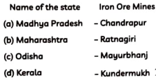
Ans. Option (d)
13. Indian Railways network is one of the longest in the world. Mahatma Gandhi said, the Indian railways “-brought people of diverse cultures together to contribute to India’s freedom struggle”. Choose the correct statement about railways system used in India.
(I) Indian Railway was introduced in 1857, when a line was constructed from Bombay to Thane covering a distance of 37 km.
(II) Indian Railways is the largest government undertaking in the country.
(III) In India, the railway system has been divided into 19 zones.
(IV) Railways has launched programme to convert the metre and narrow gauges to broad gauge.
Options:
(a) Only statement (II) is correct.
(b) Only statement (I) is correct.
(c) Only statements (II) and (III) are correct.
(d) Only statements (III) and (IV) are correct
View AnswerAns. (c) Only statements (II) and (III) are correct.
14. Golden Quadrilateral a National Highways Development Projects is constructed by –
(a) NHAI
(b) State Government
(c) National Government
(d) Local Government
View AnswerAns. (a) NHAI
Read the graph and answer the following questions no. 15-17:
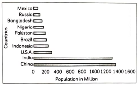
15. Identify the countries having least difference in their population?
(a) Russia and Mexico
(b) India and China
(c) Indonesia and USA
(d) Brazil and Pakistan
View AnswerAns. (d) Brazil and Pakistan
16. ldentify the Asian country that has low population.
(a) China
(b) India
(c) Pakistan
(d) Bangladesh
View AnswerAns. (d) Bangladesh
17. Which continent has the lowest number of the world’s most populous countries?
(a) Africa
(b) Europe
(c) Asia
(d) North America
View AnswerAns. (b) Europe
SECTION – B
(Questions number 18 and 19 are Source-Based Questions.)
18. Read the passage carefully and answer the questions that follows:
Services
Services occur at many different levels. Some are geared to industry, some to people, and some to both industry and people, e.g. the transport systems. Low-order services, such as grocery shops and laundries, are more common and widespread than high-order services or more specialised ones like those of accountants, consultants and physicians. Services are provided to individual consumers who can afford to pay for them. Many services have now been regulated. Making and maintaining highways and bridges, maintaining firefighting departments and Supplying or supervising education and Customer-care are among the important services most often supervised or performed oy governments or companies. Personal services are made available to the people to facilitate their work in daily life. The workers migrate from rural areas in search of employment and are unskilled. They are employed in domestic services housekeepers, cooks, and gardeners.
(A) Which services are common and wide spread?
View AnswerAns. Low-order services, such as grocery shops and laundries, are more common and widespread than high-order services or more specialised ones like those of accountants, consultants and physicians.
(B) List two services that are now being regulated.
View AnswerAns. Making and maintaining highways and bridges, maintaining fire-fighting departments and supplying or supervising education and customer care are among the important services most often supervised or performed by governments or companies.
(C) “Personal services are made available to the people to facilitate their work in daily life”. Comment
View AnswerAns. Personal services are provided to unskilled workers from rural areas, such as housekeepers, cooks, and gardeners, in unorganised domestic settings like Mumbai’s dabbawala service, etc.
19. Study the following table and answer the questions:
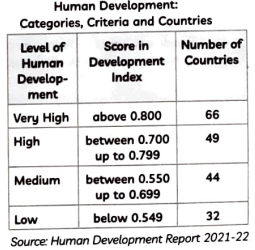
(A) ldentify the human development score for the countries classified as having Low Human Development.
View AnswerAns. The score for countries with Low Human Development is below 0.549.
(B) How many countries are classified as having a High Human Development according to the table?
View AnswerAns. 49 countries are classified as having a High Human Development with scores between 0.700 up to 0.799.
(C) Give reasons for medium level of human development in 44 countries.
View AnswerAns. The medium level of human development in 44 countries may be due to moderate access to healthcare and education, some level of economic growth, but also challenges such as inequality, limited social services, or political instability which prevent higher development levels.
SECTION –C
(Questions number 20 to 23 are Short Answer Type Questions.)
20. “The Human Development Index (HDI) ranks countries based on key areas but it is not the most reliable measure as it fails to account for distribution within countries.” Analyse this statement.
View AnswerAns. (1) Key Areas Measured by HDI: The Human Development Index (HDI) ranks countries based on their performance in health (measured by life expectancy), education (adult literacy and gross enrolment ratio), and access to resources (purchasing power).
(2) Limitation in Distribution Representation: Although HDI reflects overall achievements in human development, it does not account for the distribution of these achievements, meaning it does not reveal inequalities within a country.
(3) Impact of Life Expectancy on Human Development: A higher life expectancy at birth suggests better healthcare and living conditions in a country, directly improving its human development ranking by enhancing the health dimension of the HDI.
OR
‘People’s choices influenced in various aspects of life by a lack of human development’. Analyse the statement with examples.
View AnswerAns. Expanding people’s capabilities in health, education, and access to resources is essential for broadening their choices. Without these capabilities, their options become constrained. For example, an uneducated child cannot choose to become a doctor because the lack of education limits that possibility. Similarly, impoverished individuals often cannot access medical treatment because their choices are restricted by a lack of financial resources.
21. Study the map of trans-continental railways and answer the following questions:
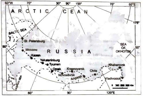
(A) Name the two places connecting west and east cities.
View AnswerAns. Trans–siberian Railways major rail route of Russia runs from St. Petersburg in the west to Vladivostok on the Pacific Coast in the east
(B) What are the importance of trans-Siberian Railways?
View AnswerAns. It is the world’s longest double-tracked, electrified transcontinental railway and the most significant line in Asia.
(C) Write one characteristic of Irkutsk.
View AnswerAns. Irkutsk is a fur centre.
22. Prepare a proposal for a smart city’s urban garbage disposal system that prioritises sustainability, cost-effectiveness, and cleanliness while utilising cutting-edge technology to increase efficiency.
View AnswerAns. To enhance urban living through efficient waste management, we propose the integration of advanced technologies focusing on sustainability, cleanliness, and cost-effectiveness. Key components include:
(1) Automated Waste Segregation: Implement machine learning algorithms for real-time waste classification and sorting, improving recycling rates and reducing contamination. Systems like Convo-Waste have demonstrated high accuracy in waste detection and classification.
(2) Solar-Powered Waste Compactors: Utilise solar energy to power compactors within bins, increasing their capacity and decreasing the frequency of collections. These compactors can significantly reduce the volume of waste, leading to fewer collection trips and lower operational costs.
(3) Data-Driven Route Optimisation: Analyse data from smart bins to plan efficient collection routes, reducing fuel consumption and operational costs. Predictive models can forecast waste generation patterns, allowing for dynamic scheduling and resource allocation.
(4) Community Engagement Platforms: Develop applications to educate residents on waste segregation, recycling, and sustainable practices, fostering community involvement and environmental stewardship. (Any three points)
23. Enumerate the reasons why an unequal population distribution indicates a close connection between physical and population issues.
View AnswerAns. The uneven distribution of population in India highlights the significant influence of physical and socioeconomic factors in shaping settlement patterns. These factors include:
(1) Relief and Topography: People tend to settle in areas with favorable topography. For instance, the Northern Plains of India, with fertile soil and flat terrain, support a large population. In contrast, hilly areas like the Himalayas have sparse populations due to challenging living conditions.
(2) Climate: Areas with moderate climates attract more people. For example, coastal regions like Kerala and the Southern Plains are densely populated due to their favourable climates.
(3) Water Availability: Access to water resources has always been a key factor. Historically, civilisations have flourished along riverbanks. For instance, cities along the Ganges and Yamuna rivers are heavily populated, while arid regions with limited water, such as Rajasthan, have sparse populations.
(4) Fertility of the Soil: Agriculture, which in turn supports higher populations, is supported by fertile soil. One of India’s most heavily populated regions, the Indo-Gangetic Plains are renowned for their fertile alluvial soil.
(5) Natural Resources: Because of the employment prospects in businesses and allied sectors, areas with abundant natural resources, like minerals, tend to draw people. For instance, the availability of minerals like coal and iron ore has resulted in industrialization and a dense population on the Chotanagpur Plateau. (Any three points)
SECTION –D
(Questions number 24 to 28 are Long Answer Type Questions)
24. What is pastoralism and how pastoral nomadism is associated with three important regions?
View AnswerAns. (1) Origin of Pastoralism: As hunting became unsustainable, humans began domesticating animals. The choice of animals varied based on regional climate and geography.
(2) Subsistence and Commercial Animal Rearing: Animal rearing today is practiced at both subsistence and commercial levels, depending on geographical and technological factors.
(3) Nomadic Herding: A primitive subsistence activity where herders rely on animals for food, clothing, shelter, tools, and transport. Nomads move with their livestock in search of pastures and water, occupying traditional territories.
(4) Animal Types by Region:
(i) Tropical Africa: Cattle
(ii) Sahara and Asiatic Deserts: Sheep, goats, camels
(iii) Tibet and Andes: Yak, llamas
(iv) Arctic and Sub-Arctic: Reindeer
(5) Key Regions of Pastoral Nomadism:
(i) Core Region: From North Africa’s Atlantic shores, across the Arabian Peninsula, to Mongolia and Central China.
(ii) Tundra Region: Eurasia
(iii) Southern Hemisphere: South-west Africa, Madagascar
(6) Transhumance: Seasonal migration from plains to mountains in summer and back to plains in winter. Practiced by groups like Gujjars, Bakarwals, Gaddis, and Bhotiyas in the Himalayas.
(7) Decline of Pastoral Nomadism: Due to political boundaries and new settlement policies, pastoral nomads and their territories are shrinking. (Any five points)
25. ‘Good governance and people-oriented policies in relation to the pillars of human development enhanced freedom and capabilities.’ Justify the statement.
View AnswerAns. Human development is supported by four key pillars: equity, sustainability, productivity, and empowerment.
(1) Equity: It ensures equal access to opportunities for all, regardless of gender, race, income, or caste. However, disparities exist, as seen in India, where many women and marginalised groups drop out of school, limiting their opportunities.
(2) Sustainability: It emphasises the need for continuity in opportunities across generations. It requires responsible use of resources—environmental, financial, and human—so that future generations enjoy the same choices. For example, failing to educate girls today restricts their future career options, affecting both their lives and society.
(3) Productivity: It refers to human labour productivity, which can be enhanced by investing in people’s capabilities. Improved education and healthcare lead to better work efficiency, making people the true wealth of a nation.
(4) Empowerment: It means the ability to make informed choices, which comes from increased freedom and capability. Good governance and inclusive policies are vital for empowering disadvantaged groups, allowing them to participate more fully in society.
OR
Evaluate the statement, ‘Taking into account both the successes and failures in human growth, methods for measuring it are continually being redesigned.’
View AnswerAns. Constant Refinement in Measuring Human Development: Methods to measure human development are continually evolving, with ongoing research to capture various elements. Researchers are exploring connections between corruption levels, political freedom, and human development in different regions. Discussions are emerging about a political freedom index and rankings of the most corrupt countries.
(1) Human Development Index (HDI): The HDI measures key achievements in health, education, and income. It reflects overall human development but does not account for inequalities or the distribution of these attainments.
(2) Limitations of HDI: While the HDI shows achievements, it does not reveal disparities or how development is spread among different groups.
(3) Human Poverty Index (HPI): The HPI measures the shortfall in human development and is a non-income based indicator. It takes into account factors like the probability of not surviving to age 40, adult illiteracy, lack of access to clean water, and the number of underweight children.
(4) Comparing HPI and HDI: The HPI often provides a more insightful view of poverty and deprivation than the HDI. Together, the HDI and HPI offer a comprehensive understanding of both the achievements and the gaps in human development across a country.
26. Assess the benefits derived from Indira Gandhi Canal (Nahar) Command Area.
View AnswerAns. The Indira Gandhi Canal, formerly known as the Rajasthan Canal, is one of India’s largest canal systems.
(1) Conceived in 1948 by Kanwar Sain, it was launched in 1958 and originates from the Harike barrage in Punjab, running parallel to the Pakistan border through the Thar Desert of Rajasthan.
(2) Spanning a total length of around 9,060 km, it irrigates a command area of 19.63 lakh hectares, with 70% utilising a flow system and the rest a lift system.
(3) The canal’s construction occurred in two stages: Stage-I covers the districts of Ganganagar, Hanumangarh, and northern Bikaner, while Stage-II extends to Bikaner, Jaisalmer, Barmer, Jodhpur, Nagaur, and Churu. Irrigation began in the early 1960s in Stage-I and mid1980s in Stage-II.
(4) This project has transformed the region’s arid land, boosting agricultural productivity but also leading to environmental issues such as waterlogging and soil salinity.
(5) The introduction of intensive irrigation has enabled the cultivation of highwater-demand crops like wheat, cotton, and rice, replacing traditional crops like gram and bajra.
(6) While the canal has led to economic benefits, these environmental challenges raise concerns about the long-term sustainability of agriculture in the region. (Any five points)
OR
‘The Hill Area Development Programmes were designed to utilise the indigenous resources of hill areas for sustainable development.’ Justify the statement.
View AnswerAns. (1) Horticulture Development: The Hill Area Development Programmes promoted the growth of horticulture by utilising the region’s favorable climate, leading to improved crop diversity and economic opportunities for local farmers.
(2) Animal Husbandry and Poultry: These programmes encouraged animal husbandry and poultry farming, providing sustainable livelihood options for the hill communities and reducing dependence on traditional farming alone.
(3) Plantation Agriculture and Forestry: Plantation agriculture and forestry were developed to harness the natural resources of the hills, leading to conservation efforts and economic benefits through sustainable timber and non-timber products.
(4) Small-Scale and Village Industries: The programmes supported the establishment of small-scale and village industries, which helped generate employment and fostered local entrepreneurship in areas like handicrafts and cottage industries.
(5) Ecological and Social Considerations: The development plans were designed with an emphasis on topographical and ecological needs, ensuring that economic activities were sustainable and did not harm the fragile hill environments.
27. ‘Non-conventional sources of energy can contribute more to providing more sustainable and environmentally friendly energy in India’. Justify the statement with suitable arguments.
View AnswerAns. Non-conventional energy sources provide sustainable alternatives to exhaustible fossil fuels like coal, petroleum, and natural gas.
(1) Renewable energy sources include solar, wind, geothermal, tidal, and biomass, which are environmentally friendly and inexhaustible.
(2) Solar energy is harnessed through photovoltaic cells and solar thermal technology, with significant potential in Gujarat and Rajasthan.
(3) Wind energy is generated by converting wind’s kinetic energy into electricity via turbines and is already being used in Rajasthan, Gujarat, Maharashtra, and Karnataka.
(4) Tidal energy has great potential along India’s coasts, though it remains underdeveloped.
(5) Geothermal energy is derived from the earth’s internal heat, with a geothermal plant operating in Manikaran, Himachal Pradesh.
(6) Nuclear energy is produced from uranium and thorium, with key nuclear plants located in Tarapur, Kalpakkam, and Rawatbhata.
These energy sources are expected to provide more sustainable, eco-friendly, and cost-effective solutions for future energy needs.
OR
‘Conservation of minerals are essential for Indio’. Substantiate the statement with suitable arguments.
View AnswerAns. Sustainable development requires balancing economic growth with environmental protection.
(1) Traditional resource usage generates large amounts of waste and leads to environmental issues.
(2) Sustainable development emphasises the need to protect resources for future generations.
(3) There is an urgent need to conserve resources to ensure their availability for the future.
(4) Alternative energy sources, such as solar, wind, wave, and geothermal, are inexhaustible and should replace exhaustible resources.
(5) Recycling scrap metals is crucial, especially for metals like copper, lead, and zinc, where India’s reserves are limited.
(6) Using scrap metals reduces the need for new extraction and enables metal recycling.
(7) Substitutes for scarce metals can help reduce their overall consumption, preserving reserves.
(8) Strategic and scarce minerals should be exported less to conserve them for longterm domestic use.
(9) Effective resource management and adopting alternative energy sources will aid in achieving sustainable development goals. (Any five points)
28. ‘There are problems of Slums and Urban Waste Disposal in developing countries like India’. Explain this statement.
View AnswerAns. Issues faced by slums in urban India
(1) Migration and Housing Affordability: Many individuals migrate from rural areas to urban centres seeking livelihood but cannot afford proper housing due to high rent and land costs.
(2) Poor Living Conditions: Slums are characterised by dilapidated houses, inadequate ventilation, and poor hygienic conditions.
(3) Lack of Basic Amenities: Residents face severe shortages of essential services such as drinking water, electricity, and toilet facilities.
(4) Health Hazards: Open defecation, unregulated drainage, and overcrowded streets contribute to significant health risks and environmental concerns.
(5) Economic Vulnerability: Most slum inhabitants work in low-paid, high-risk jobs within the unorganised sector, limiting their economic stability.
(6) Nutritional Deficiencies: The population is often undernourished, making them susceptible to various diseases and health issues.
(7) Educational Barriers: Due to poverty, families struggle to provide proper education for their children, perpetuating a cycle of disadvantage.
(8) Social Issues: Poverty leads to vulnerabilities such as drug abuse, alcoholism, crime, vandalism, and apathy, resulting in social exclusion.
(9) Environmental Degradation: Slum areas are often located in environmentally incompatible regions, exacerbating living conditions and health risks. (Any five points)
OR
Give reasons for the successful ecological restoration and improvement of human health in Daurala.
View AnswerAns. (1) Community Participation: The active involvement of the twelve thousand residents of Daurala in recognising their health issues and supporting ecological restoration efforts was crucial for the success of the initiatives.
(2) Stakeholder Collaboration: Effective collaboration among NGOs, industrialists, government officials, and community representatives facilitated the development of sustainable solutions to the pollution problem.
(3) Health Status Surveys: The NGO conducted a door-to-door survey to assess the health of residents, which provided essential data that guided the restoration efforts and highlighted the urgency of addressing groundwater contamination.
(4) Infrastructure Improvements: Enhancements, such as increasing the overhead water tank’s capacity and laying a new pipeline for potable water, directly addressed the water quality issues faced by the community.
(5) Environmental Initiatives: The implementation of rainwater harvesting structures and the planting of 1,000 trees contributed to improving the environment and diluting contaminants in the groundwater, leading to better health outcomes for residents.
SECTION –E
(Questions number 29 and 30 are Map Based Questions having 5 sub-parts each.)
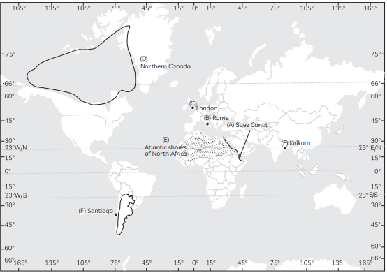
29, On the given political map of the World, seven geographical features have been marked as (A), (B), (C), (D), (E), (F) and (G). ldentify ANY FIVE with the help of the following information and write their correct names.
(A) Shipping Canal
(B) An important international airport of Italy.
(C) An International Seaport
(D) An area of subsistence gathering in South America.
(E) A nomadic herding area
(F) An airport in South America
(G) A major seaport
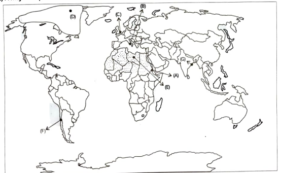
Ans.
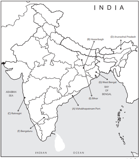
30. Locate and label ANY FIVE of the following geographical features on the political outline map of India with appropriate symbols:
(A) An important seaport in Andhra Pradesh.
(B) A copper mine in Jharkhand
(C) Ratnagiri iron ore mines
(D) State with lowest population densty
(E) The state with highest population density
(F) An international airport of Karnataka
(G) The state leading in the production of jute.
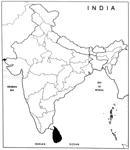
Ans.